It's About to Get Bumpy
An inflection point has been reached with DOGE cuts to weather balloon observations

I have a single topic post today that should have all professional pilots, passengers, airline management, and other stakeholders extremely concerned. The National Weather Service announced late last week that weather balloon launches would be either eliminated or cut across several weather forecast office sites.
The reason given was staffing — a problem introduced by the Trump Administration’s “DOGE” agency when it terminated over 1000 jobs from the National Oceanic and Atmospheric Administration (NOAA). The National Weather Service (NWS), National Hurricane Center (NHC), and other weather and climate related services are run by NOAA.
Weather balloon launches (technically called “radiosonde observations”) are done typically twice per day at NWS forecast offices across the country. The observations are crucial to measuring key atmospheric data through all layers of the atmosphere. The data is fed into large computer atmospheric models that process the data into forecasts.
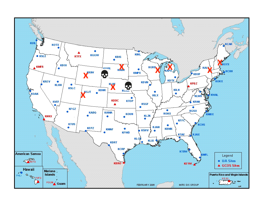
Cuts announced late last week fully cancel any observations from Omaha, NE and Rapid City, SD, while cutting observations in half at Aberdeen, SD, Grand Junction, CO, Green Bay, WI, Gaylord, MI, North Platte, NE, and Riverton, WY.
[Here are the links to the notices from the NWS: Notice 1 and Notice 2]
The cuts to NWS employees already raised concerns regarding weather forecast and warning capabilities. Getting rid of actual observations will have severe consequences.1
Will It Be That Bad?
Several weather experts think this is bad. Forecasts will take a hit in fidelity (i.e. they simply will not be as accurate). ABC News’ article covering the weather balloon cuts does a nice job rounding up some of those opinions.
In addition to the forecast of weather at departure and destination, pilots also rely on accurate forecasts of the weather conditions enroute — specifically the winds and temperatures at the high altitudes airplanes cruise at. This information aids and assists in fuel planning, as well as forecasting and anticipating areas of turbulence.
Degrading the ability to accurately forecast high altitude weather means increasing the probability of:
turbulence encounters and turbulence-related injuries
fuel miscalculations and resulting flight diversions
re-routes and diversions due to unforecast weather
hits to on-time performance due to inaccurate winds aloft forecasts
But…Why?
Let’s be clear. There is an endgame for DOGE and the Trump Admin, and ignorance of short term consequences is all a part of their strategy. The more this hurts, the easier it will be for them to say an agency isn’t doing their job. This careless agenda is being carried out with the goal of privatizing several parts of the US Government. The ones that cost the most money because of their critical essence to safety, security, and quality of life for all Americans will also make billions of dollars in profit for the private corporations that take over these functions.
Think about it. How many times have you heard in the news (or even from your local politician) that these government services should be “privatized”?
Social Security
Medicaid/Medicare
Student Loans (overseen by Department of Education)
Home Loans (already partially done via Fannie Mae/Freddie Mac)
Air Traffic Control
National Weather Service
National Park Service
Postal Service
Public Schools
Veterans Affairs
Federal Prisons
….and the list goes on and on.
What Can Be Done?
For starters, spread the word. Talk to your fellow pilots, email your CEOs, and let your friends and family members know that travel across the United States by air is about to get worse.
Then tell them to call and write to members of congress. Tell them to stop Trump and DOGE from degrading aviation safety, and making it harder for weather forecasters to do their jobs — which in the end is a safety issue.
Fly Safe!
This is mainly an aviation-related consequences post. But look at the map. Severe weather season is about to erupt across the northern plains. Upper air observations are one of the most crucial tools forecasters use to determine where and when severe thunderstorms, and their threats — large hail, damaging winds, and tornadoes — are most likely to occur. Cutting the observations st GJT, RIW, LBF, OAX, HMR, and ABR is just downright reckless.


You're completely wrong.
This long-haul pilot thinks we'll be perfectly fine.
But there's only ~30 yrs flying going into that gut feeling of mine; maybe I'm just an idiot...